
Memorial Day weekend took a dangerous turn for millions across the southern United States, from Oklahoma to Mississippi, as a powerful storm system unleashed heavy rains, hail, and tornadoes. Over 12 million people were placed on high alert for flash flooding, widespread power outages, and hazardous conditions impacting multiple states.
Allie Barkalow Memorial Fund: Supporting Final Wishes and Honoring a Cherished Santa Rosa Resident
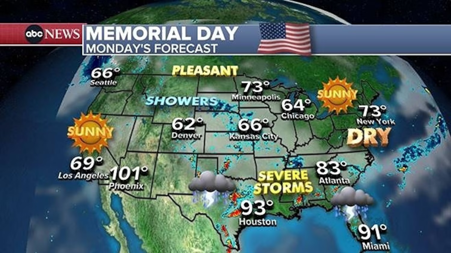
Tornadoes and Hail Cause Widespread Damage
The overnight hours of Memorial Day saw six confirmed tornado touchdowns in Texas and one in New Mexico, alongside large hailstones as big as six inches in diameter reported in Texas. Violent storms left extensive damage in their wake, causing around 100,000 utility customers across Texas and Alabama to lose power by Monday afternoon.
Heavy Rainfall Triggers Flash Flood Warnings
Heavy rain drenched major urban centers into Monday morning, with Dallas, Texas, and Shreveport, Louisiana, receiving between 1 to 4 inches of rain. Some areas in Oklahoma saw rainfall totals of 4 to 6 inches, prompting flash flood warnings and emergency responses. Meteorologists warned that the stalled storm system would continue to impact the southern region throughout the day, with persistent risks of damaging winds, hail, and possible tornadoes stretching from Texas eastward to Alabama.
Storm Watches and Flood Alerts Remain in Effect
Severe storm watches were active for Baton Rouge and much of eastern Louisiana and south-central Mississippi through 7 p.m. Monday. Forecasts indicated winds reaching up to 65 mph, posing a threat of property damage, downed trees, and widespread power disruptions. Tornado threats within the storm complex added urgency to safety warnings issued by emergency officials.
Emergency Services Urge Vigilance
Authorities urged residents in affected areas to remain alert and prepared to take immediate action. The National Weather Service highlighted the rapidly changing conditions and advised people, especially those in flood-prone or low-lying neighborhoods, to monitor local forecasts closely. Saturated soils have significantly reduced the land’s ability to absorb further rainfall, increasing flood risks.
Northeast Sees Clearer Weather — But Wet Weather Looms
While the southern U.S. faced storms, cities in the Northeast such as New York and Boston enjoyed pleasant weather, with temperatures around 70 and 60 degrees Fahrenheit, respectively. However, meteorologists predict the storm system responsible for southern severe weather will move northeastward by Tuesday, bringing showers and isolated thunderstorms to mid-Atlantic and Northeastern regions by Wednesday. Rainfall is expected to continue into early June, potentially disrupting outdoor activities.
Causes and Preparations for the Severe Weather
Meteorologists describe the weekend’s severe weather as a convergence of atmospheric conditions, including abundant moisture from the Gulf of Mexico and unstable air masses conducive to thunderstorms and tornado development.
Emergency management teams, utility companies, and local governments have activated preparations, including pre-positioning rescue crews, ensuring power restoration teams are on standby, and spreading public safety information urging residents to avoid floodwaters and secure their properties.
Ongoing Recovery and Safety Concerns
In areas like Texas and Louisiana, where flash flooding has damaged homes and infrastructure, recovery efforts continue amid ongoing storms. Officials emphasize that flash floods are among the deadliest weather hazards, capable of overwhelming roads and communities, and strongly caution against unnecessary travel during such conditions.
Climate Context: Increasing Frequency of Extreme Weather
Scientists note that extreme weather events like this have become more frequent and intense due to climate change, with warming temperatures increasing atmospheric moisture and contributing to heavier rainfall. The southern U.S., particularly Gulf Coast inland areas, has experienced a rise in severe thunderstorms and flooding events over recent decades.
Community Impact and Response
The storms disrupted holiday plans for thousands, with flash flood warnings and tornado watches complicating travel and outdoor events. Power outages affected homes and businesses, impacting communication and essential services. Local authorities coordinated cleanup, power restoration, and shelter provisions for displaced residents.
Community solidarity shone through as neighbors and volunteers rallied to support those affected, showcasing resilience in the face of severe weather.
Safety Recommendations for Residents
The National Weather Service and emergency officials recommend that residents:
- Avoid driving through flooded roads, as even a few inches of water can sweep vehicles away.
- Secure outdoor items and ensure proper drainage around homes.
- Prepare emergency kits with supplies for potential extended outages or evacuations.
- Develop a safety and communication plan with family and loved ones.
- Stay informed through reliable sources such as weather apps, radio, and official social media channels.
Conclusion: A Reminder of Nature’s Power and Preparedness
The Memorial Day weekend storms highlight both the raw power of nature and the vital importance of preparedness. While millions in the southern U.S. face immediate threats from flash floods, tornadoes, and high winds, others in the Northeast enjoy a brief respite before the next weather front arrives.
Resources and recovery efforts continue in affected areas, demonstrating the strength and cooperation of communities responding to natural disasters. As the nation moves beyond this turbulent holiday weekend, the focus remains on safety, recovery, and building resilience against future extreme weather events.